Natural Solutions Tool
EXPLORE THE TOOL
The Natural Solutions Tool is free to use but it needs ongoing investments to maintain it. Please consider a donation to support our efforts to manage this unique and valuable resource. Please click here.
In 2021, the Greater Chicago Watershed Alliance launched an 18-month effort to develop the Natural Solutions Tool. This free, publicly available tool was custom-built to empower decision makers and community leaders to help drive watershed wide investments in nature-based stormwater solutions while also addressing related environmental, social, and public health goals.
Founded upon five modeling objectives that drive us towards healthy, equitable, biodiverse, protected, and connected landscapes and communities, the Natural Solutions Tool incorporates over 100 data layers that allow users to visualize and customize data to address complex environmental challenges and substantiate the work we are doing to address them.
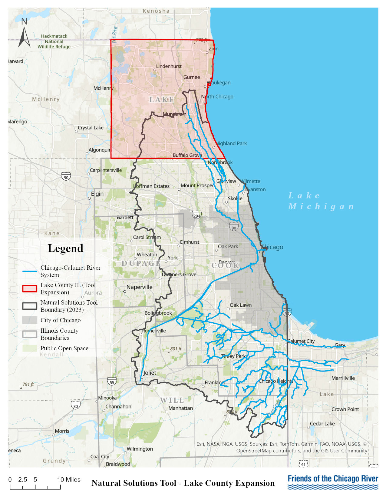
Expanded into all of Lake County, IL
In fall of 2025, the award-winning Natural Solutions Tool was expanded to incorporate all of Lake County, Illinois thanks to generous support from the Daybreak Fund. Friends of the Chicago River and the Trust for Public Land worked closely with Lake County government agencies, nonprofits, data practitioners, educators, and community advocates to ground-truth the Tool expansion to ensure the data accurately reflects the existing needs and opportunities for the county.
When the Tool first launched in 2023, it included most of Cook County but only partial coverage of Lake County, which is the headwaters of the Chicago-Calumet River system and therefore critically important. With the new funding, the Tool now fully encompasses Lake County—including key environmental justice investment communities and the Lake Michigan Watershed. The expanded Tool also includes a new analysis topic for agricultural land protection using data provided by the Chicago Metropolitan Agency for Planning.
See a map of the Tool’s expanded boundary below and explore it here.
Friends of the Chicago River and the Trust for Public Land (TPL) are thrilled to be recognized as a Climate Champion by the Chicago Innovation Awards for our leadership in creating the Natural Solutions Tool. The Climate Champion Award was presented in November 2023 in Chicago. The Natural Solutions Tool also received a Chicago Wilderness Dr. George B. Rabb Force of Nature Award in January of 2024.

The Tool was custom built using local data to meet our goals and the choices of modeling objectives and data layers to use were the result of a months-long, collaborative process which included a Technical Advisory Team of 30+ technical experts and members of the Watershed Alliance Steering Committee including Friends' executive director, planning director, policy manager, and planning and GIS specialist.
The Natural Solutions Tool analysis covers of all or parts of four Northeastern Illinois counties: Cook, Lake, DuPage, and Will (all of Lake and most of Cook). It provides understanding of:
- Detailed modeling objective layers searchable down to an unprecedented parcel level;
- Data overlays such as core habitats, political boundaries, natural areas, and trails;
- Age, race, and economic demographics; and
- Regional needs and opportunities.
Since its launch in 2023, the Tool has been used to inform decision making, understand existing conditions, advise University research efforts, reveal opportunities and priorities for project implementation, advance advocacy and community protection, substantiate grants and investments, and in educational spaces with youth through Friends’ GIS mapping & environmental justice lesson plans.
Check out a live demonstration of the Natural Solutions Tool on Friends’ YouTube.
Trainings
Friends' staff provides training opportunities, those interested can email naturalsolutionstool@chicagoriver.org to set up a group or individual training.

Friends’ Amy Heldman providing a training of the Natural Solutions Tool at a Chi Hack Night in November of 2023.
The Tool is set to receive annual updates, please reach out to naturalsolutionstool@chicagoriver.org with data requests to be included in a future update or if you notice any updates needed to the existing data layers.